Hayward fault at South Hayward
 A small gully on the hillslope above has been Holy Sepulchre Cemetery has been offset by fault movement nearly 3 meters as illustrated by the red stakes. This offset probably represents surface displacement in the 1868 Hayward earthquake and accumulated creep, plus possible offset in an unknown earthquake before 1868.
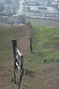 Continuing northward , this old fence at Holy Sepulchre Cemetery in south Hayward has been offset by fault creep more than 3 feet since it was built in the nineteenth century.
 On undeveloped hillslopes, the fault trace is marked by streams that are bent, almost at a right angle, by right-lateral movement of the fault. Right-lateral means that the land on the far side across the fault moves to the right. The stream channel was originally straight. But thousands of years of fault slip and creep have moved the stream eighty meters or about 260 feet to the right.

In places, the Hayward fault can be observed at the surface as a line of green vegetation when the grass on the hills dries out in the springtime. The line of vegetation remains green because of seeps and springs formed along the fault.Springs form because the rock in the fault zone has been pulverized by fault movement and altered to clay. This pulverized rock and clay, called fault gouge, forms an underground dam. Water moving underground accumulates against the fault and comes to the surface as seeps, springs, or ponds.
posted by Shawn O'Brien at
3:46 PM
![]()
![]()

0 Comments:
Post a Comment
Subscribe to Post Comments [Atom]
<< Home